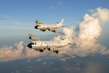
 Here we are a little over a week into the hurricane season with no storms in sight! That's good, because we are far from ready. Why not, you may ask. Here's the story.
One of our P-3s, Ms. Piggy, was converted into a flying chemistry laboratory and deployed to Ontario California to participate in a two-month air quality study of the Los Angeles basin and high desert east of there, the San Joaquin Valley, the Sacramento Valley and the Imperial Valley. Here's a glimpse of that. This photo shows the aircraft at Ontario International Airport, California. You might recognize the mountain in the background as being Mt. Baldy if you are a regular watcher of the Sprint Cup racing series. This is the backdrop for the 2nd race run in Fontana just down the road at the California Raceway.
Our purpose there was to participate in an extensive study of the air quality in the region working with California Air Resources Board and four other aircraft from NOAA, NASA, Navy

and the Department of Energy. The cooperation of the FAA allowed us to fly at remarkably low altitudes throughout the Los Angeles area, which is as you imagine very congested with commercial air traffic, private planes and even parachutists,

especially on the weekends. The flight track shown here is that of a flight we made on May 14th in the LA basin and out over the Pacific Ocean where we sampled air flowing into the basin, clouds in the marine boundary layer and ship exhaust plumes, a source of considerable pollution. This flight was 6.5 hrs. in duration, but some of our flights into the northern valleys are 8 hrs. or more, as shown to the right. It's been a great project and is scheduled to end on June 23, after which time the aircraft will return to Tampa and its home to be retrofitted with the special instrumentation for our hurricane program.

It's been a very interesting project, and I was glad I had the opportunity to fly on a couple of the flights. Here are a couple of pics from these two flights. The one to the left clearly shows the type of haze and pollution in the LA Basin - sorry California folks. And, if you wonder what causes it, you already know that a lot of it

comes from cars, trucks, etc., while some of it is industrially driven. But, I bet you didn't know that a lot of the haze particles develop from a combination of motor vehicle exhaust and the ammonia emanating from large concentrations of livestock in feed lots as shown to the right. This feed lot is actually

in the San Joaquin Valley, but similar lots in and around Chino, CA, just south of Ontario (see Google Map image left), are a big part of the problem.
As we go about our flying business, a lot of which is at low altitudes, we often have to make low approaches into airports, bothsmall and large, in order to sample the air at the very lowest levels. To the right is a shot of such an approach into a small airport in the San Joaquin Valley. On a previous flight we did two low approaches into LAX (Los Angeles International) where the big boys fly. Now you know why I don't want to give this up and retire.
We have done some other interesting flying this past month as we await the first storm of the season. That will be the topic of my next posting.
And don't forget, you can enlarge the pictures in the Blog by clickingon them. Just remember to hit the back button to return to the blog


No comments:
Post a Comment