Thursday, August 5, 2010

Bye-Bye Bonnie; Hello and Goodbye Colin

Hello all - haven't had much to write about in the last couple of weeks because not much has been happening in the tropics. Bonnie went bye-bye. She wasn't much to write home about, which is a good thing considering the fright it gave folks in the Gulf connected with the BP Deepwater Horizon oil spill. Dodged a bullet on that one.

T.S. Colin came along for part of one day early this week. I believe that a forecaster, in a weak moment in the wee hours of the morning, made an error in judgment in upgrading the depression to a named storm. It was quickly downgraded back to a depression later that day. It's currently a tropical wave NNE of Puerto Rico but could re-intensify into a T.S. as it moves off to the north. The latest visible satellite image shows it getting its act together again. No worries for the U.S., though. As the forecast tracks indicate, Colin will be racing off to the NE in a few days time. Our friends in St. John's Newfoundland may bet a piece of the action, but they are hardy souls who thrive on bad weather and moose meat.
Not much else going on in the tropics. Don't be fooled, though. It's only early in August. In 2004 we didn't have our first hurricane until the 1st of August, and it turned out to be one of the busiest seasons on record. Conditions are right in the tropics, so hold on to your hat. The forecasting group at Colorado State Univ. are sticking with their earlier predictions of 18 named storms and 10 hurricanes. So far the record is 3 and 1, which means we have a lot more in the pipeline.
Had a nice four-day vacation in Wisconsin last week. It was supposed to have been a five-day vacation at the Maloney cottage on Green Bay and two in the air going and coming. Turned out to be 4 and 3 as out of four flights, two were cancelled and the other two were late by as much as three hours. But, we were blessed with great weather, nice people and a lot of fun. No complaints - except to Delta Air Lines.

Friday, July 23, 2010

TS Bonnie

It's too bad we had to waste the name Bonnie on this system, but the NHC nevertheless upgraded TD#3 to Tropical Storm (TS) Bonnie. I suppose if we are going to meet the forecast for numbers of named storms we have to get the numbers up.

Anyway, we have TS Bonnid which, as I write this, is moving through S. Florida with the heavies rains right over Miami - home for me. From the satellite picture it doesn't look like much, and as you can see from the current NHC track, it's a fast moving storm which should pass into the Gulf this afternoon and make landfall in Louisiana/Mississippi early Sunday morning. That's a good thing as it will give everyone here in Florida part of the weekend to relax. To see a larger version of these images, just click on them. Remember to hit your back button to return to the blog.

As to our flight schedule for Bonnie, we did have a G-IV flight planned for this afternoon at 1:30 pm and several P-3 flights over the next couple of days. The Hurricane Center, which tasks the Gulfstream G-IV missions, has decided not to waste another flight on Bonnie and has cancelled today's mission. I'm still waiting to here from the other folks about the P-3 flights. The first one is scheduled to depart this afternoon at 4:00 pm and the second at 4:00 am tomorrow morning (same aircraft - different crew). The plan is to repeat these on Saturday/Sunday, but with the storm being ashore early Sunday morning, I think we are limited to only three total missions. Frankly, I see no need for any of these flights considering the condition of the storm and its rapid movement, but that's not my call. I will certainly question the need, but I will provide the support if needed.

More later.

Thursday, July 22, 2010

AL97 Just Won't Go Away

At 9:03 this morning, the NHC raised the probability of AL97 developing into a depression within 48 hours from orange (40%) to red, near 100%. At 11:00 am today AL97 will be classified as TD (tropical depression) #3. They will begin issuing advisories and putting up tropical storm watches along the South Florida coastline and Fla. Keys at that time. The Air Force reconnaissance aircraft will begin flying canned patterns into the system, determining among other things the exact center position every three hours. Our NOAA G-IV will also fly again this afternoon and evening, as they did yesterday, and I expect they will be tasked again for tomorrow. Today's pattern for the G-IV is shown to the right.
Please not that the forecast tracks have been moved further south and now have the storm moving through the Florida Straits and into the Gulf of Mexico. While this typically is cause for alarm along the Gulf coast, the intensity forecasts do not bring this storm to hurricane strength - yet.

We are awaiting word on tasking for the NOAA P-3 for tomorrow. The G-IV has been tasked once again for Friday. Since there will be frequent changes in events related to this storm, I shall continue to update the blog at appropriate times.

Wednesday, July 21, 2010

AL97 Begins to Fall Apart

As expected, it was an interesting day for AL97 and plans for us to fly this system. While the G-IV did fly its mission this evening, leaving MacDill AFB at 1:30 pm and still out there even though it's after 9:00 pm. The flights on the P-3 scheduled to begin at 4:00 am in the morning and continue every 12 hours for at least two days were, however, cancelled because the system weakened during the day for several reasons (shear, dry air entrainment, Saharan dust, etc.). The G-IV is still on the schedule for a second flight tomorrow, but I suspect it too will be cancelled in the morning.

So what did the flight today accomplish? As explained in my last posting it flew a mission to the east and southeast of Florida. The track is shown in that posting. I spoke of the plane and the dropsonde, but a visual is more explanatory, so I'm showing both here. The plane is shown to the right in the margin. The dropsonde is shown in a cut-away view and in a drawing suspended
from its parachute. As I have indicated before, the sonde is launched from the aircraft, falls towards the surface on its drogue chute at a speed of about 3,000 ft. per minute, all the while transmitting data back to the aircraft. The sample rate is two times a second (2 Hz) for temperature, humidity and pressure, and 4 times a second (4 Hz) for wind speed and direction. From 45,000 ft. it takes about 15 minutes for the sonde to reach the surface.
These data are processed onboard the aircraft and transmitted via high-speed satellite communications back to the NOAA computing center in Camp Springs, MD where they are assimilated (big word) into the model runs done every six hour. The data from this flight will go into the 00Z (8:00 pm) forecast run this evening.
As you can see from the forecast tracks issued at 18Z (2:00 pm) this afternoon where there were no dropsonde data, quite a spread has developed in the various track forecasts. The forecast with the dropsonde data in it will be published
later this evening, and we'll see what impact this flight had. Hopefully it will bring many of those lines into more agreement with each other. I'll let you know in the morning. Please bear in mind, though. Forecasting is not an exact science, and when the flapping of a butterfly's wings in China can ultimately affect the weather in Miami, FL, one has to find that elusive butterfly in order to do a better job. We'll be sure to be out with our nets for the next couple of days.
Well, here's a piece of luck. The forecast runs done at 8:00 pm have already been published and are shown at the right. These have the dropsonde data from the G-IV in them. Please note that the tracks are in much better agreement with each other than those shown in the 2:00 pm runs which did not contain any sonde data - again proving the value of this aircraft and its role in hurricane forecasting. Guess we caught a couple of butterflies.
The bad news is that the tracks are carrying whatever happens to AL97 into the Gulf and across the Deepwater Horizon oil spill area. Most of the models continue to weaken the system, but we'll have to wait a few days to see what it does when it gets to the Gulf. Keep your fingers crossed.

The Tropics Heat Up - Along Comes AL97


The tropics are starting to heat up. AL97, a disturbed area of weather north NW of Puerto Rico, is providing some excitement here and at the NHC, and while this morning it doesn't look too interesting, folks in Miami are warily watching it. The latest forecast tracks, seen to the left, leave no doubt about where it is headed - the only question is whether it will be a named strom by the time it gets there on Friday. Hopefully nothing serious develops since Friday is the day I return from Tampa to Miami and we prepare for our trip to Wisconsin next Monday.

At present AOC has been tasked by the Hurricane Center to begin flying its G-IV jet this afternoon at 1:30 pm on a track that is shown here. This will be about an 8 1/2 hour flight at altitudes from 41,000 ft. to 45,000 ft. AOC personnel will be dispensing GPS droopwindsondes at each of the points shown. These devices fall on a small parachute to the surface and radio atmospheric data back to the aircraft for processing and immediate transmission from the aircraft. The profile data (temperature, humidity, pressure and winds) are then utilized in a number of the forecast models used to predict the track of the storm. Since I covered this ground in my 2008 Blog, you may want to link back to it for a wealth of information on our facility, its aircraft and personnel. Just click on the month and posting in the right panel ts, hat may be of interest. The blob starts with the latest posting in that year and works back to the first one in May. For blow-ups of most of the picture and diagrams, just click on them. Remember to hit your back button to return to the blog.

I had promised to talk to you about AL96, but it didn't amount to anything even though we did fly research missions into and around it with one of our P-3s and the G-IV. Hopefully AL97 will have the same fate. More on that later.

Monday, July 12, 2010

The Anatomy of a Turboprop Engine and AL95

Hello all -

It's been a busy couple of weeks around AOC and the tropics. When last I wrote we had experienced an engine problem on a flight into Tropical Storm Alex and had to suspend the remaining several planned flights into that system. Well, as expected there was a serious failure in the gearbox - that very complex part of the engine that connects the turbine or jet section of the engine to the propeller. Hence, we had to swap out the engine for a spare unit that we keep on hand. As it was, our crack maintenance team was able to accomplish the change and the test flight in a 12-hour shift. That was good because another Gulf disturbance, AL96, was close on its heels. But, I'll save that for later. Thought I'd use this opportunity to talk about the anatomy of a turboprop engine such as we have on our P-3s.

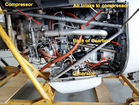
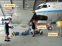
Simply put, a turboprop engine is a jet engine connected to a propeller by a very complex gearbox. Also attached to several of the engines are generators, which supply the necessary power for operating the aircraft and scientific equipment aboard, as well as engine driven compressors (EDC) which provide for the pressurization onboard as well as helping to cool the fuselage. Some of these are shown in the following pics.
The left shot shows the entire engine and prop assembly on the aircraft. The right photo shows some of the components in the engine after removal. The view is the reverse side of the engine.

Here are a couple of additional photos - the first showing a mechanic preparing the spline of the shaft that comes from the gearbox to the propellor; the second showing the after section or exhaust from the turbine; the third of the location where the engine will be inserted onto the wing mount; and finally the entire motor being lifted on the hoist in preparation for insertion into the mount.


And there you have the cliff notes on a turboprop engine like the ones we use on our P-3s. Simply put, air comes in the intake on top of the engine behind the spinning prop, enters the compressor to build the pressure as it enters the turbine. There fuel is injected and ignited driving the connection to the very complex gearbox which in turn spins the propellor. 90% of the thrust to drive the aircraft through the air comes from the props and only 10% from the jet exhaust. Unlike regular jet engines, these run at a constant speed, and thrust is obtained by changing the pitch of the prop, thereby grabbing more air and thrusting it under the wing giving you speed and lift. Elementary, I'd say.

Enough for this episode. I'll talk about AL96, which was last week, tomorrow.

Best to all.

Wednesday, June 30, 2010

Tropical Storm Alex - A Storm to Forget


By now I had high hopes of putting up a posting lauding the performance of our P-3 and G-IV aircraft and crews in and around Tropical Storm/Hurricane Alex, but alas we were only partially successful. But, let me first set the stage.

In my last posting I mentioned that the disturbance that movedacross the Atlantic over the past couple of weeks had finally turned red on the NHC site. It finally developed into Tropical Storm Alex, weakened as it moved across the Yucatan Peninsula, and then began to strengthen again as it moved into the Bay of Campeche in the Gulf of Mexico. Based on the widespread variations from a number of the model forecasts, as shown here, there was considerable concern that thiswould become a hurricane and possibly totally disrupt the oil spill relieve efforts going on in the north central Gulf.Alsoshown here is the five day forecast put out by the NHC as of last Saturday, and for the most part their forecast was dead-on.) This peaked the interest of the scientists and forecasters, and as a result we were tasked to fly both our P-3 and G-IV on Monday and Tuesday. The P-3 was scheduled for 4 am and 4 pm on Monday, using two different crews, with a repeat of these takeoff times for Tuesday. The G-IVhad a more gentlemanly takeoff time of 1:30 pm on both days. All flights were scheduled for 8 hours each.

The purpose of the P-3 flights was to develop horizontal x-sections of horizontal winds from data collected with theaircraft'stail doppler radar to be used to improve hurricaneintensity forecasts. The G-IV was to engage in hurricane surveillance missions to collect, process and transmit dropsonde data for real-time inclusion in track forecast computer model runs. The planned tracks for the first missions are shown here.

Let me just say that the two flights flown by the jet, the first shown on the left, were outstanding, and the dropsonde data collected, processed and transmitted via satellite to the modeling centers went a long way in bringing the forecast tracks closer together and more in line with the official NHC track shown above. That was the bright spot in our Alex operation, and I should be, and I am, pleased with this. The P-3 effort was anything but.

Monday was a black day for our lone P-3 at MacDill AFB in Tampa (The sister ship to this one was stuck in Colorado with an engine problem). OK. So we were down to one plane and two crews (the 2nd flight crew borrowed from the plane in Colorado) to fly five scheduled missions, all back to back. Monday wasn't even an hour old when I received a call at 12:50 a.m. during which I was told that the storm was too close to the Mexican shoreline to fly and the flight had to be cancelled. Ever try to get in touch with a bunch of people at one o'clock in the morning? By that time 90 percent of them were either already at the hangar or on their way. And, how would you feel getting to work at that time and being told that the flight wasn't going and you had to go home? Fortunately, most of the people could stay on and accomplish much of their normal ground duties very early in the day.

So here comes the 4 pm crew. Preparations went well; spirits were high; folks were looking forward to the first storm flight of the season. Although things got off to a rocky start with an instrument problem and then a balky engine that wouldn't readily start, the plane departed for Alex about 45 minutes late. About 3 hours into the flight just as the plane and crew were about to make their first pass through the storm, the flight engineer, who sits between the two pilots, noted an excessive vibration in the #1 engine emergency shutdown (E) handle (see left picture). Since such vibrations often indicate an impending failure of the engine, the decision was made to shut-down the engine and return to base (see picture from my files of how it looks). Click and see.

And that's the way it was this past Monday. Let's hope for better days ahead.

Thursday, June 24, 2010

It's Gone Red

So how's are system in the Caribbean progressing? Well, this evening the NHC raised the probability of it becoming a tropical storm to level RED, or 60 percent. You can check out these probabilities at the NHC website. The probabilities are updated four times a day.

If you are looking for the forecast tracks you can go to the Colorado State University Tropical Cyclone Guidance website and click on track and intensity forecasts. Here's the latest model track forecast for the current system, AL93. Just click on frame 1 by the early track guidance. Do the same by the intensity guidance.

That's about it for tonight. I'll update tomorrow when I have more information. Don't forget to click the back button after looking at the links in order to return to the blog.

Have a good evening.

Tuesday, June 22, 2010

Is This the Beginning?

For almost two weeks the National Hurricane Center (NHC) has been tracking a wave moving very slowly across the Atlantic. When first seen it looked fairly potent and NHC was very excited, giving it a high probability of developing into the Atlantic season's first named storm (Alex). While the wave looked great (see right) and even showed signs of rotation, it faced some real difficulties. First, it was too early in the season for a Cape Verde storm, and it soon encountered strong westerly winds aloft and cooler sea surface temperatures. This caused a weakening of the wave, and it barely held together as it continued its westward march across the Atlantic.

But, now it's in the central Caribbean, and because some of the
forecasts show it moving into the Gulf of Mexico and strengthening into a hurricane, renewed interest is being shown by the NHC. I've shown here the model forecast from yesterday, 21 June, for both the track and the intensity. You can rely reasonably well on the track forecast, but since we don't do very well with intensity forecasts you can take that with a grain of salt.
So we have to ask ourselves, is this really the start of the Atlantic hurricane season? With the heightened concern over the oil spill in the Gulf, any storm there will be dealt with using every resource available. If it does become a hurricane I am certain that both our G-IV and available P-3 will be pressed into service. Looks like its boom or bust. Stay tuned.

Tuesday, June 15, 2010

The Gulf Wars

What about the Gulf? Well, our group, the Aircraft Operations Center, has been heavily involved in the Deepwater Horizon oil spill in the Gulf of Mexico. We have routinely been flying three of our smaller aircraft, two Twin Otters and a King Air 350ER doing remote sensing of the spill and monitoring the marine mammal situation thee. One of our P-3s, Kermit, has been collecting data on the loop current with weekly 9 hr. flights during which during which vertical profiles of temperature, current and salinity have been taking collected from expendable probes deployed from the aircraft such as you see here being loaded into one of the belly launch tubes on the aircraft. In excess of 60 of these probes are jettisoned out of the aircraft during each of these long missions.

And, our California P-3 loaded with its sophisticated chemistry gear was not overlooked in NOAA's effort to utilize all resources possible to characterize the nature of the spill. Ms Piggy,
as she is so aptly named, was recalled last Monday to fly a series of two missions in the area in and around the spill to determine the quality of the air that would be eventually blowing ashore someplace along the Gulf coast. The plane arrived Monday night, flew missions on Tuesday and Thursday and then returned to Ontario, CA where it is flying four additional flights there to conclude the two-month CalNex project. One of the flights from the two Gulf missions is shown to the left, and Ms. Piggy's departure from MacDill AFB in Tampa, FL on its return flight to Ontario California is shown to the right.

And now we wait. Ms. Piggy will return from California on the 26th of June, undergo a major maintenance inspection and be re-instrumented with all of her hurricane gear to be ready by August 1. We're hoping the tropics hold off until then, but judging from the disturbance noted in the mid-Atlantic this week, the season may come earlier than hoped. We'll have to wait to see.

Next posting will be when something interesting occurs. Until then, I hope you enjoy what's already been posted.


Tuesday, June 8, 2010

In the Beginning - So what are we up to here in early June?

Here we are a little over a week into the hurricane season with no storms in sight! That's good, because we are far from ready. Why not, you may ask. Here's the story.

One of our P-3s, Ms. Piggy, was converted into a flying chemistry laboratory and deployed to Ontario California to participate in a two-month air quality study of the Los Angeles basin and high desert east of there, the San Joaquin Valley, the Sacramento Valley and the Imperial Valley. Here's a glimpse of that. This photo shows the aircraft at Ontario International Airport, California. You might recognize the mountain in the background as being Mt. Baldy if you are a regular watcher of the Sprint Cup racing series. This is the backdrop for the 2nd race run in Fontana just down the road at the California Raceway.

Our purpose there was to participate in an extensive study of the air quality in the region working with California Air Resources Board and four other aircraft from NOAA, NASA, Navy
and the Department of Energy. The cooperation of the FAA allowed us to fly at remarkably low altitudes throughout the Los Angeles area, which is as you imagine very congested with commercial air traffic, private planes and even parachutists,
especially on the weekends. The flight track shown here is that of a flight we made on May 14th in the LA basin and out over the Pacific Ocean where we sampled air flowing into the basin, clouds in the marine boundary layer and ship exhaust plumes, a source of considerable pollution. This flight was 6.5 hrs. in duration, but some of our flights into the northern valleys are 8 hrs. or more, as shown to the right. It's been a great project and is scheduled to end on June 23, after which time the aircraft will return to Tampa and its home to be retrofitted with the special instrumentation for our hurricane program.
It's been a very interesting project, and I was glad I had the opportunity to fly on a couple of the flights. Here are a couple of pics from these two flights. The one to the left clearly shows the type of haze and pollution in the LA Basin - sorry California folks. And, if you wonder what causes it, you already know that a lot of it
comes from cars, trucks, etc., while some of it is industrially driven. But, I bet you didn't know that a lot of the haze particles develop from a combination of motor vehicle exhaust and the ammonia emanating from large concentrations of livestock in feed lots as shown to the right. This feed lot is actually
in the San Joaquin Valley, but similar lots in and around Chino, CA, just south of Ontario (see Google Map image left), are a big part of the problem.

As we go about our flying business, a lot of which is at low altitudes, we often have to make low approaches into airports, bothsmall and large, in order to sample the air at the very lowest levels. To the right is a shot of such an approach into a small airport in the San Joaquin Valley. On a previous flight we did two low approaches into LAX (Los Angeles International) where the big boys fly. Now you know why I don't want to give this up and retire.
We have done some other interesting flying this past month as we await the first storm of the season. That will be the topic of my next posting.
And don't forget, you can enlarge the pictures in the Blog by clickingon them. Just remember to hit the back button to return to the blog


Monday, June 7, 2010

The Basics - Aircraft, Crews and Instrumentation

Before the season starts I want to tell you, or at least show you where to go, about our hurricane aircraft, crews, instrumentation, etc. All of this is explained in some detail in my 2008 hurricane blog so click on the link and peruse my old site for that information. This should keep you occupied for a spell while I gather some information together regarding some very exciting work we are doing with regard to air quality studies in the Los Angeles basin and adjoining valleys to the east and north of there as well as the Deepwater Horizon oil spill in the Gulf of Mexico. Information on these projects will be provided in the next day or do.

Friday, June 4, 2010

An Ominous Forecast

Greetings all.

As we begin the 2010 hurricane season i is appropriate to point out that the forecasts issued by both NOAA and the Colorado State University (CSU) are a bit ominous in the sense that they call for a very active season. NOAA predicts that there is a 70% probability that each category range will be as follows:
  • 14-23 Named Storms,
  • 8-14 Hurricanes
  • 3-7 Major Hurricanes
  • An ACE range of 155%-270% of the median.
The last category, ACE, is the Accumulated Cyclone Energy index and a measure of the total overall seasonal activity. It takes into account both the intensity and duration of named storms, and the high range indicated does not bode well for the hurricane season.

Why such a difference over last year? One of the major reasons is the collapse of El Nino, that warm pool of water in the Pacific that produces shearing westerly winds aloft over the Caribbean and Western Atlantic that inhibit the development of storms in thee areas. El Nino has been replaced by cooler waters called La Nina, thus reducing this shear. We'll have to see how this plays out over the course of the season, but these conditions are very reminiscent of those in 2005.

The NOAA Aircraft Operations Center, to which I am affiliated as Chief, Programs staff and its Hurricane Program Manger, has a stable of 3 aircraft engaged in a wide variety of atmospheric, oceanographic and environmental research and operations as well as 10 other aircraft involved in marine mammal surveys, remote sensing of the environment and aerial mapping of our shorelines. This blog will be primarily directed to the activities of the first three aircraft, two WP-3D Lockheed Orions and a Gulfstream G-IV, as they are the principal platforms involved in NOAA's hurricane research and operational programs.

As I begin this blog, please bear with me as I must learn to master the art of blog creation once again. I prepared an extensive 2008 hurricane season blog with considerable detail about these two types of aircraft, and I will be referring you to that blog for background information. First I need to get organized, and then we'll get on with the season.